This September, Swiss Geo Energy and Ad Terra Consultancy conducted a detailed seismic survey, also called a geophysical campaign, across 104 km² in the Eclépens region, north of Lausanne. This article explores the methods for developing preliminary 3D imagery with the collected data. These findings help improve our understanding of the area’s underground structures, which is crucial for both geothermal energy development and geological research.
SGE’s and Ad Terra Consultancy’s teams oversaw the processing of the acquired 3D seismic data, using sparse velocity analysis to fast-track the analysis of how acoustic waves travel through the ground, along with standard parameters suitable for this type of survey geometry and geological settings. The data was refined using filters to reduce noise and condition the data before moving it to the preliminary pre-stack time migration (PreSTM) imaging stage.
Understanding PreSTM Imaging
PreSTM imaging is a sophisticated technique used in seismic data processing. This method is crucial for improving the quality and accuracy of the geological images obtained from seismic surveys. The basic idea behind PreSTM imaging is to reposition seismic data to their correct locations in the subsurface before it is combined or “stacked.”
Revealing hidden structures
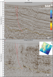
The fast-track processing products reveal structures in deep Triassic sediments (3+ km depth) that were previously undetected in vintage 2D lines (refer to the figure below, indicated by yellow dashed lines). Our teams are investigating various hypotheses, including salt diapirs (salt domes), faults, salt stringers, and faults reactivated by recent Alpine tectonics. Detailed structural interpretation, which is currently underway, will clarify these questions.
Comparative insights from new 3D seismic data
While the vintage 2D lines starting from the shallow Cenozoic levels show discontinuous reflectors with a chaotic signature, the new 3D seismic volume distinctly outlines a lineated basin structure towards the southeast. These findings provide a detailed glimpse into the region’s geological history and serve as crucial research topics for both the geothermal industry and academia to refine existing geological models and explore seismic activity.
Challenges in interpretation using 2D lines
Would you be able to accurately interpret the fault (dashed red line) using only a 2D line? Precise interpretations are essential, especially when these structures are potential targets for drilling. To thoroughly plan wells and reduce risks in a geothermal project, it is advisable to supplement the vintage 2D seismic data with 3D surveys, where feasible.
Upcoming advanced seismic processing
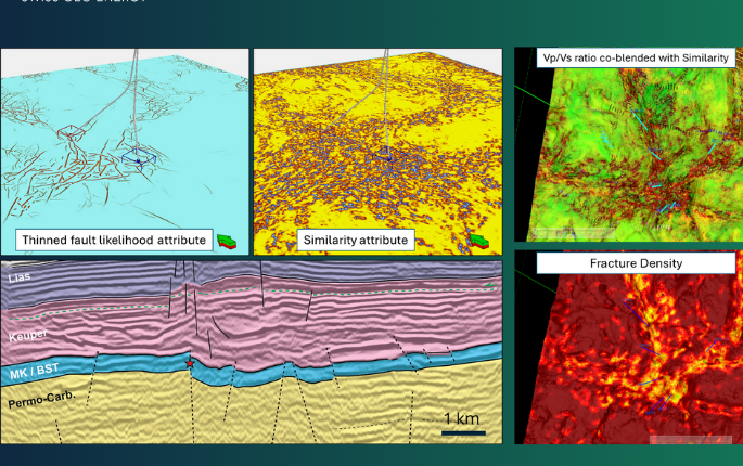
The complete seismic processing will incorporate several advanced techniques beyond the initial pre-stack time migration (PreSTM). These include anisotropic pre-stack depth migration (PreSDM), a method that accounts for the direction-dependent velocity of seismic waves, Common Reflection Angle Migration (CRAM) and diffraction imaging, methods that enhance the fracture characterisation of seismic images. Currently, the depth processing is underway, with results expected by Summer 2024. Meanwhile, the geological interpretation is being updated daily.


